Tuesday, July 21, 2015

Pakistan

Many people today seem to forget that there were once two Pakistans, one called East Pakistan, the other called West Pakistan, the consequence of Hindu-Moslem enmities when the Raj - the British Empire in India - came to an end in 1947. No one was happy with the arrangement; Gandhi even refused to attend the independence celebrations, because he was devastated that a single country could not have been formed, still named India, with Hindus and Moslems living together in peace, harmony and cotton-weaving.

Peace, and passive resistance as an alternative to war, both died with Gandhi. Wars between the Hindus and the Moslems were fought in 1947 and again in 1965, with proxy wars continuing in the divided Kashmir and Bengal regions to this day.

In the meanwhile, the Awami League had become established in 1949, campaigning for East Pakistani independence, which it finally achieved in theory in 1970, only for implementation of the election result to be delayed by a cyclone that killed a half a million people, the refusal of the government in West Pakistan to accept the vote, and then the kidnapping by them of Sheikh Mujibur Rahman, their leader; they held him for nine months, during which time Bengali nationalists launched a guerrilla war against the Pakistani army, India took the Bengali side, Bangladesh was declared an independent nation, and Sheikh Rahman released to serve as President, later as Prime Minister, which office he used, in 1974, to establish a one-party state, close down all political parties except his own, and most newspapers except those who volubly supported him. Seven months later he was assassinated and, guess what, the military took power.

So much for East Pakistan, about which you can read more under its new name, Bangladesh. West Pakistan is what remains, now minus the "West", one of many examples that could be cited to show that the political geography of planet Earth was not achieved by intelligent design, or not by humans anyway. As the adjacent map demonstrates, it is a tiny sleeve of land, squashed between the giants of India and Iran, with the anarchy of Afghanistan to the north-west, the even greater anarchy of rival warlords and Indians in Kashmir, and then the Himalayas...but what the map does not show is that this very small country (just 300,000 square miles, the size of Namibia) has 191 million people living in it, making it the sixth most populous country in the world (Namibia, by contrast, has 2.3 million).

Not surprising then that Pakistan's seventy year history is one of military coups, dictatorships, corruption, war-lords and general mayhem, best told through the history of its Constitution. This took four years to create, but only two more before it was suspended (by Ayub Khan), then replaced (by Ayub Khan in 1962), though that second version did not actually take effect until 1973, only to be suspended again four years later (by Zia-ul-Haq in 1977), and reinstated in 1985. Or we could take a look at Pakistani history through the eyes of the military historian: military coups which imposed martial law and then turned their leader into a civilian President took place in 1958 (lasted until 1971), 1977 (lasted until 1988), and 1999 (lasted until 2008), so the next one is due in 2016 or 2017.

Pakistan, like India, is also a nuclear power, and more importantly not a signatory to the non-proliferation treaty (of the eight nuclear nations, the USA, UK, China, Russia and France are signatories, India, Pakistan and North Korea are not; Israel is not on either list because Israel continues to deny having any nuclear capacity). The Pakistani possession of the bomb appears to have been significantly overlooked by the Obama administration when it engaged in talks with Iran about its nuclear programme; Iran's eastern border is with Pakistan, and that, far more than the Israel factor, is why the Iranians want/need nuclear weaponry. They at least can count what Obama and Kerry have apparently forgotten, that Pakistan was known to have stockpiled up to one hundred and twenty warheads by the end of 2014, and has sufficient reserves of prepared fissionable material to expand that stockpile to two hundred. India probably has fewer, but its nuclear programme is so "highly classified" that figures are hard to come by; the current belief of the tracking agencies is between ninety and one hundred and ten. But If India and Pakistan can have the bomb...


Marks For: 9000 (the number of runs scored in test matches by Younis Khan, as of the time of writing this)

Alternative Marks For (Marks Against are obvious from all the above paragraphs, and far too many to enumerate): 6 - the number of places in Pakistan designated by UNESCO as World Heritage Sites (the Archaeological Ruins at Moenjodaro, the Buddhist Ruins of Takht-i-Bahi and Sahr-i-Bahlol, Taxila, the Shalamar Gardens and Fort in Lahore, several historical monuments at Makli, and Rohtas Fort)


You can find David Prashker at:
http://theargamanpress.com/
http://davidprashker.com/
http://davidprashker.net/
https://www.facebook.com/TheArgamanPress

http://davidprashkersprivatecollection.blogspot.com
http://davidprashkerssongsandpoems.blogspot.com
http://davidprashkersbookofdays.blogspot.com/

http://davidprashkersartgallery.blogspot.com/


Copyright © 2015 David Prashker
All rights reserved
The Argaman Press

Thursday, July 16, 2015

Switzerland

Strange, strange place. I have known countless Swiss during the sixty years of my life, and they have all, without exception, been lovely, charming people, who speak several languages with interchangeable fluency, regard skiing as the principal activity of the gods on Mount Olympus (or should that be Mount Engelberg), and smile with ironic boredom when you ask if they possess a cuckoo clock (they all do).

But then you challenge them about their tradition of neutrality, about the universally-known truths of their banking system, which sees no evil, hears no evil, and therefore cannot be accused of practicing any evil, and they respond by describing the gun they keep at home for their annual return to reserve duty in the conscripted peacekeeping forces of their military (why does a neutral country need a conscripted army anyway?).

Or you ask them, why did it take until 2002 to join the United Nations; and why have you not joined the European Community (the answer to both questions is, again, neutrality, and banking)?

And then, because if you are me you like to press the most controversial and provocative of questions: is it true that the largest party in your multi-party democracy, in the European country which has the largest number (20%) of foreign nationals living in it, is the Swiss People’s Party, whose main platform is anti-immigration, and which approved the banning of minarets on mosques after a referendum in 2009? When the British Prime Minister, in a speech in the Australian Parliament in November 2014, announced his government’s intention to restrict immigration from certain parts of Europe, and former Prime Minister John Major gave the same speech on the same day, the head of the European Commission responded by saying it was illegal to do so under EC regulations; a 2014 referendum in Switzerland approved by a large majority precisely such a restriction. No wonder they haven't joined the EC - they'd be thrown out.

There is Switzerland, and there is Sweden, two European countries with high standards of living and excellent provision of all the civilised basics of life. One achieves it through a “socialised” economy, the other through isolationist racism, closed doors, and an economy driven by money-laundering, tax-havening, and the financing of terrorism. Two models. Take your pick.


Marks for: 314 (the number of pieces in Hans Meister's 1991 version of the Swiss Army Knife, claiming the record for the world's largest version of Switzerland's one and only true contribution to world civilisation, given that you can't really count the now-obsolete cuckoo clock)

Marks against: 1934 (the year in which the Swiss Banking Law was passed, establishing "account confidentiality" with legal protection. Click here for the case for the defence)


Copyright © 2015 David Prashker
All rights reserved
The Argaman Press


Wednesday, July 1, 2015

Saint Martin


Or Sint Maarten, to restore its original Dutch spelling and pronunciation. In fact, it was Spanish first, having been sighted by Christopher Columbus in 1493 and claimed for Spain, but it was the Dutch who first settled the island and exploited its salt deposits. The Spanish then retook it in 1633, fought with the French and Dutch over it, and gave it up in 1648. As with all Caribbean islands, its history for the next two hundred years was one of cotton, tobacco, and sugar plantations worked by African slaves; Napoleon abolished slavery on the French side of the island; the Dutch finally did the same on their half in 1863. After the Second World War, and now a free port, Sint Maarten joined with several other Dutch Caribbean possessions to become the Netherlands Antilles. Following a referendum in 2000, it then became a self-governing country within the Kingdom of the Netherlands, the change not formalised until October 2010, when the Dutch parliament dissolved the Netherlands Antilles.

The island's official website describes itself as "the capital of duty-free shopping", and offers watersports, beaches and calypso nightlife as its contribution to the improvement of human existence. What, no race-riots to selfie, no shanty towns to blog, no ethnic tensions to postcard, no religious rivalries to crusade for or against? It claims to be Paradise on Earth, and of course it isn't; but apparently it may be as close as we will get.


Marks for: 0 (the total number of customs duties, VAT, and other indirect taxes you can expect to pay).

Marks against: 0 (the total number of customs duties, VAT, and other indirect taxes you can expect to pay).


You can find David Prashker at:
http://theargamanpress.com/
http://davidprashker.com/
http://davidprashker.net/
https://www.facebook.com/TheArgamanPress

http://davidprashkersprivatecollection.blogspot.com
http://davidprashkerssongsandpoems.blogspot.com
http://davidprashkersbookofdays.blogspot.com/

http://davidprashkersartgallery.blogspot.com/


Copyright © 2015 David Prashker
All rights reserved
The Argaman Press


Saint Lucia

First sighted by Columbus as late as 1501, a French colony after 1635, ceded to Britain in 1814 as part of the Treaty of Paris, turned by the British into another of their innumerable sugar plantations, worked by slaves from Africa until slavery was abolished in 1834, it was one of the earliest of Britain’s overseas territories to become independent, being allowed a form of representative government in 1924, a constitution in 1936, universal suffrage in 1951, and finally self-governance in internal affairs in 1967, paving the way for full independence in 1979. By then the British had lost interest anyway, because the production of sugar cane was no longer viable, and so they closed it down and tried bananas instead. With less than 200,000 people inhabiting the island, and living in the shadow of its two volcanic peaks, there is little for anyone to be politically adversarial about, and anyway the weather's too hot and the beaches too inviting. A minor spat in 2003 when the Parliament voted to replace the Oath of Allegiance to the British monarch with a pledge of loyalty to itself; but the British got over it, eventually.


“Marks for” are very high indeed, for the splendid sulphur springs which are every tourist’s preferred destination, and for the arbitrary, haphazardous and chanceful fact that Derek Walcott, Nobel Prize for Literature laureate in 1992, grew up in St Lucia.


Marks against: None that I can think of; it doesn't even get a listing by Human Rights Watch, and Amnesty International only mentions it in passing, and that as one of the countries that had absolutely no one on death row - the kinds of listing, or absence of listing, that every civilised country should aspire to. Maybe having such a very different type of flag is also significant!


You can find David Prashker at:
http://theargamanpress.com/
http://davidprashker.com/
http://davidprashker.net/
https://www.facebook.com/TheArgamanPress

http://davidprashkersprivatecollection.blogspot.com
http://davidprashkerssongsandpoems.blogspot.com
http://davidprashkersbookofdays.blogspot.com/

http://davidprashkersartgallery.blogspot.com/


Copyright © 2015 David Prashker
All rights reserved
The Argaman Press


Saint Kitts and Nevis

St Kitts is really St Christopher, named by Columbus for his patron saint rather than as personal self-aggrandisement.

Nevis is named for the mountain which occupies most of the centre of the island, and which does, if you get the angle right, and the sun is in a certain direction, and the clouds are being helpful, really does look a little bit like Mount Ben Nevis in Scotland; but not that much (actually I made that up; it's really an abbreviation of Nuestra Senora de la Nieves, Our Lady of the Snows, in Spanish, though no snow has ever been recorded on the island, and is never likely to be, given where it lies in the world – so my explanation is just as unreasonable).

The islands occupy that geographical region known as the Lesser Antilles, and are really part of the Leeward islands, though they like to think of themselves as separate, and would quite like to be separate from each other, and not just by the two miles of shallow waters that physically separate them. Britain gave them independence in 1983, with the administration based on St Kitts, which the Nevisians resent; proof that partition doesn't work, not just in big and complex places like Palestine and Pakistan, but even on two tiny islands like these.

Like most of the islands in the region, they spent centuries producing the richest and most valuable crop in the world – slaves; the islands were the headquarters for the trade in the Caribbean, with between six and seven thousand passing through the islands every year. Today those slaves' descendants are more or less the only inhabitants, the indigenous Arawaks and Caribs having been wiped out long ago, and the British and the indentured Irish on Nevis, and the French who took control of St Kitts for a while, having gone home. The last of the sugar plantations which the slaves worked was closed in 2005, leaving tourism, money laundering, off-shore tax havening and drug-transportation as the main sources of income.

The island of Anguilla was supposed to be part of this structure, which the British first set up in 1967, but the Anguillans didn't like the fact that it was centred in St Kitts, threw the St Kitts police force out, and seceded.


Marks For: This entire business of trying to give marks to countries for their contribution to human progress and development is becoming a bit pointless, don't you think?

Marks Against: Fewer than some, more than others.


You can find David Prashker at:
http://theargamanpress.com/
http://davidprashker.com/
http://davidprashker.net/
https://www.facebook.com/TheArgamanPress

http://davidprashkersprivatecollection.blogspot.com
http://davidprashkerssongsandpoems.blogspot.com
http://davidprashkersbookofdays.blogspot.com/

http://davidprashkersartgallery.blogspot.com/


Copyright © 2015 David Prashker
All rights reserved
The Argaman Press

Tuesday, June 30, 2015

Saint Helena, Ascension, and Tristan da Cunha

Despite the Napoleonic connection, Saint Helena is not a French property, but a British Overseas Territory, included in the triad that is also the Ascension Islands, and Tristan da Cunha.

Saint Helena was entirely uninhabited when the Portuguese discovered it, either in 1502 or 1503, depending on which version of history you prefer. The 1502 version gives the discovery to the Spaniard João da Nova, who was employed by the Portuguese; the 1503 version claims that da Nova actually discovered Tristan da Cunha, and that it was Estêvão da Gama who discovered Saint Helena. Whichever it was named it for the mother of the Roman Emperor Constantine, a fanatical Christian who convinced her son to accept baptism and to make Christianity the religion of the Roman Empire, the reason why the Vatican is still in Rome today.

The Portuguese never settled the island, but simply used it as a convenient mid-Atlantic port, until it was rendered inconvenient by attacks from Dutch and British fleets; the Dutch claimed the island in 1633, but also never settled it; the British then took it in 1657, when Oliver Cromwell gave the East India Company a charter to seize the place. When the English monarchy was restored, the fort was named Fort James, and the main town Jamestown, in honour of the king.

Why exactly the Dutch and British then spent decades fighting over the island, seizing it, and seizing it back, is unclear, as the place was so utterly uninhabitable - drought, infertile soil, collapsed forests, and vast amounts of ghastly vermin - that the British commander at one point recommended the transfer of the entire population, which was about a thousand people including the half that were slaves, to Mauritius. A perfect place for a penal colony, if you thought about it. But neither the British nor the Dutch did think about it, until they needed somewhere to put Napoleon Buonaparte after the Battle of Waterloo had finally ended his tyranny - or his liberation of Europe from feudal monarchism, if you prefer that version of history. Napoleon, for the information, was initially lodged at the Briars Pavilion, owned by the British Superintendent of Public Sales for the East India Company, a man
 named Balcombe; the pavilion was located on the grounds of the family's home. Napoleon stayed there until his permanent home, Longwood House, was completed; he died there on 5th May 1821, probably of stomach cancer. The only member of the Balcombe family who could speak French was their thirteen year old daughter, Betsy; she acted as translator and later wrote a memoir. Sadly Betsy became rather enamoured of Napoleon, and her parents took a liking to him as well, which led the governor, Hudson Lowe, to suspect the Balcombes of not being properly Britishly stiff-upper-lip and Francophobe, and had them dismissed from the island. Or perhaps he just liked their house, and wanted it for his own; once the Balcombes were gone, he sequestered it for his own use, and it remained the Admiralty on the island forever afterwards. The garrison then served as a prison during the Boer war of 1900-1903, by which time Saint Helena's value as a way-station in the Atlantic had diminished to zero, because all ships now went by way of the Suez Canal.


Ascension Island was discovered at the same time as Saint Helena, and likewise ignored until it found a useless sort of use, in this case as a garrison to protect Saint Helena, in case anyone should think to launch a rescue of Napoleon. No one ever did. After this, it served as a provisioning station for the Royal Navy's West Africa Squadron when said force was out on anti-slavery patrol, and during the Second World War the UK allowed the US to construct an airfield there to enable planes to refuel en route to Africa, and as a base for anti-submarine operations in the South Atlantic; later the Americans used it as a space tracking station. But the real moment of glory for Ascension came in 1982, when Queen Margaret of England sent the largest Navy in her nation's history to rescue another irrelevant island in the Atlantic from being returned to its rightful owner, and the Ascensions provided the midway staging-post and refuelling point. Viva Las Malvinas, Viva Las Ascensionas!

And last, and by every means least, Tristan da Cunha, which sounds like a single island, and is, but it is also the overall name for a group of islands, of which Nightingale, Inaccessible, and Gough make up the remainder. Before that, Tristan da Cunha was Tristão da Cunha, who was born in Portugal somewhere around 1460, and might have been the first Viceroy of Portuguese India, only a mysterious case of temporary blindness prevented him from taking up the post; or it may have been the thought of living forever on tandoori and chutney, which is hot and spicy and fine if you like it, but the pasta was being perfected in Rome, and serving as King Manuel I of Portugal's emissary to Pope Leo X, which he did from 1514, was definitely a better option. In the period between the blindness and the Roman appointment, da Cunha led a Portuguese naval fleet into the southern Atlantic, ostensibly to find and rescue the explorer João da Nova, whose ship had become stranded en route home from India, in practice to discover lands which could be claimed for Portugal, and to garrison them to consolidate the claim. Socotra, which are four islands that now belong to Yemen, were the first that he claimed, followed by Madagascar, Mozambique, and finally the group of islands that bear his name. His mission came to a convenient end, given his Roman aspirations, in Barawa in Somalia, when da Cunha was wounded trying to add that city to his collection.


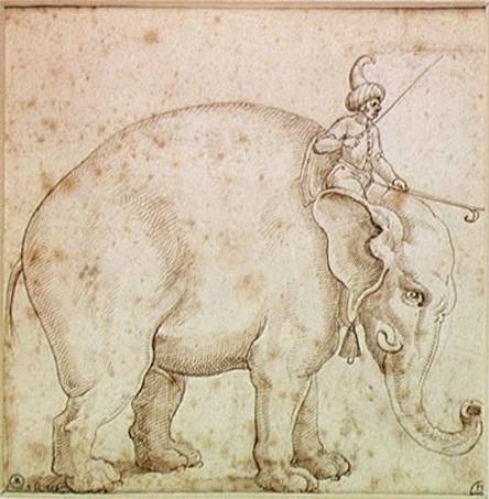
And so to Rome, where King Manoel wanted to show Pope Leo just how substantial and significant the Portuguese world empire now was - a case of sibling-rivalry with Spain, though actually Portugal was all but bankrupt as a consequence of its attempts at imperialism. No one would suspect it from the triumphant arrival of da Cunha and his entourage in Rome, the details of which we know from the diaries of his secretary, the poet Garcia de Resende. The embassy consisted of one hundred and forty people, and it travelled in a very public pilgrimage that started in Lisbon and marched to Alicante, on the Spanish east coast, sailed to Majorca, then across the Tyrrhenian Sea to Rome, which it entered on March 12th 1514 in what could have been the July 4th parade outside Macy's in New York, but transferred in time and space. The generally preferred adjective among historians is "extravagant", and it included large amounts of exotic wildlife, displays of wealth from the Indies, members of the entourage dressed "Indian style", and at its vanguard, pride of the show, an elephant named Hanno, King Manoel's personal gift to the Pope - though it was unclear where he was going to keep it as the Roman Zoo was four hundred years in the future - as well as forty-two other creatures, including two leopards, a panther, several parrots, a gaggle of turkeys, and some extremely rare Indian horses which did not like the Italian climate. Hanno carried a platform of silver on his back, shaped as a castle and containing a safe with royal gifts, including vests embroidered with pearls and gems, and coins of gold minted for the occasion. The Pope welcomed the procession at Castel Sant'Angelo, where the elephant knelt down three times in reverence and then, following a wave of his Indian mahout (keeper), sucked into its trunk the contents of a bucket of water, and spat it out again over the assembled Cardinals. Six weeks after this ostentatious but illusory display of wealth, King Manoel made confession of his nation's bankruptcy, and had his emissary in Rome request a bail-out from the Pope, much in the manner of contemporary Portugal with the European Union. The Pope responded with rich gifts, in gratitude for which Manoel sent first a ship full of Indian and Arabian spices, and then another containing an Indian rhinoceros. Unfortunately the rhinoceros didn't like the Italian climate any more than did the Indian horses or the elephant, and it caused such trouble on-board that the ship sank off Genoa, and the last anyone heard of the rhino was a portrait by Albrecht Dürer. 

As to the island which da Cunha named after himself, it was garrisoned by the British in 1816 for the same reason as Ascension Island, and then resumed its former existence as an out-of-the-way and uninhabited nowhere until that status was formalised when it became a World Heritage Site in the late 20th century. South Africa leases a small corner of Gough Island for a meteorological station.


Marks For: You decide

Marks Against: Ditto


You can find David Prashker at:
http://theargamanpress.com/
http://davidprashker.com/
http://davidprashker.net/
https://www.facebook.com/TheArgamanPress

http://davidprashkersprivatecollection.blogspot.com
http://davidprashkerssongsandpoems.blogspot.com
http://davidprashkersbookofdays.blogspot.com/

http://davidprashkersartgallery.blogspot.com/


Copyright © 2015 David Prashker
All rights reserved
The Argaman Press


Monday, June 29, 2015

Saint-Barthélemy

Yet one more French dominion far from the native land, Saint Barths, as it tends to be abbreviated, or Ouanalao, as it should properly be called, is just ten square miles of tropically hot weather in the midst of the Caribbean, midway between Saint Martin and Saint Kitts. It was first discovered in 1493, by Christopher Columbus, who everybody knows was secretly French; Colombe named it for his brother Bartolomeo, which likewise is self-evidently a French name. And the place was packed with French people, otherwise known as indigenous natives, or Taino, an ancient offshoot tribe of the Franks who also inhabited Cuba, Jamaica, Hispaniola, Puerto Rico and the riviera between Nice and Saint Tropez.

The trouble with Christopher Columbus was that he liked to find places which he thought were India, but weren't, and plant a Spanish flag close on the beach, but close enough to his boat that he didn't get sand between his toes, and then leave again, aware that English pirates were sneaking up to loot any gold or silver he might have, but blindly oblivious to the French who were also sneaking up behind him, less interested in the gold and silver than in settling these new lands, tearing down the Spanish flag, and claiming them for France. It took them until 1648 to do this on Saint-Barthélemy, and then, deciding that cultivating cacao was all very well, but fighting the Taino was not, they sold the island to Sweden, who renamed the largest town Gustavia, after their King Gustav III, and made it a free port - well, that was the name they used, though it is unclear how a place can be, at one and the same time, a "free port" and a place which operates under an "Ordinance concerning the Police of Slaves and free Coloured People", even though it has no plantations. The last slave on the island was freed in 1847, which was fourteen years after the British, but still several decades ahead of most of the other Caribbean islands, let alone the Americas.

The island made a very comfortable living for the Swedes, less from the cacao than by providing a trade and supply center during the colonial wars of the 18th century; so successful, indeed, that France bought the island back in 1877, placing it under administration from nearby Guadeloupe.

So there you have it - a Taino-Spanish-French island, whose street and town names are Swedish, so that there should really be four and not three crowns on its coat of arms. In 2003 the populace of the island voted to secede from Guadeloupe, and in 2007 the island became a French overseas collectivity.


Marks for: 7, based on the significant contributions made to human civilisation by the Taino people. These are, in total, the addition of the words barbecue ("barbacoa"), hammock ("hamaca"), canoe ("kanoa"), tobacco ("tabaco"), yucca ("yuca"), potato ("batata"), and hurricane ("juracán") into European language and culture.


Marks against: 0, based on the significant contributions made to human civilisation by the French, Spanish and Swedish settlers of Saint-Barthélemy.


You can find David Prashker at:
http://theargamanpress.com/
http://davidprashker.com/
http://davidprashker.net/
https://www.facebook.com/TheArgamanPress

http://davidprashkersprivatecollection.blogspot.com
http://davidprashkerssongsandpoems.blogspot.com
http://davidprashkersbookofdays.blogspot.com/

http://davidprashkersartgallery.blogspot.com/


Copyright © 2015 David Prashker
All rights reserved
The Argaman Press